MARINE
& OFFSHORE


MARINE & OFFSHORE
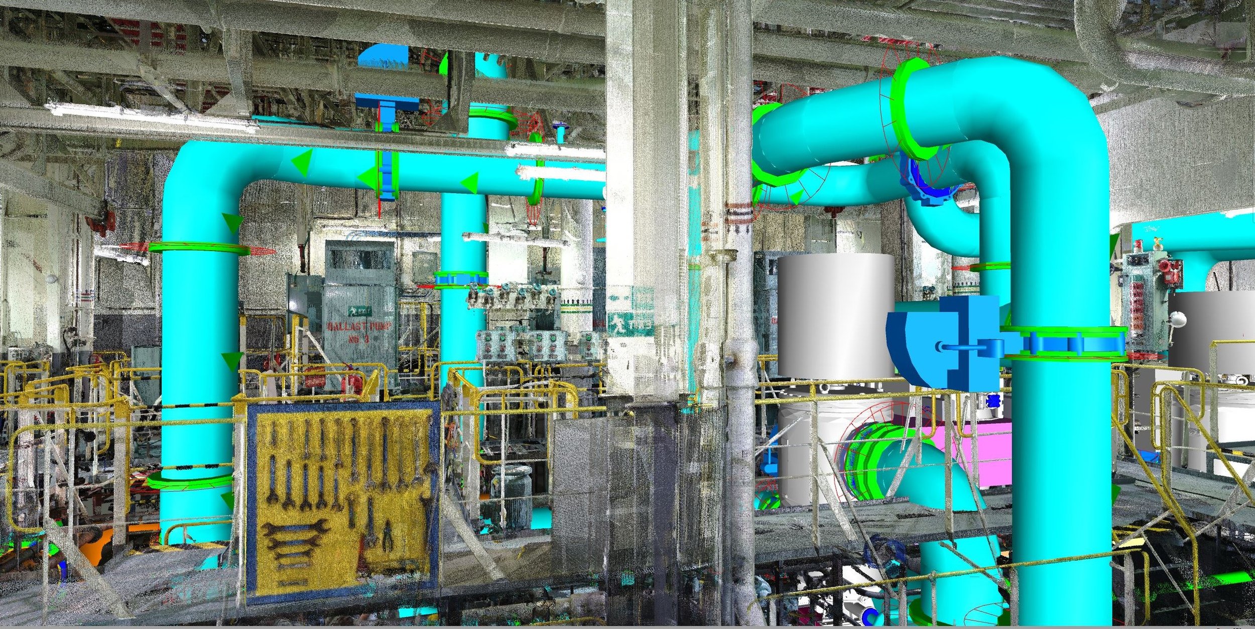
Through 3D laser scanning, survey tasks required for the inspection, installation, retrofit, conversion, and maintenance of offshore installations and ships can be performed rapidly and, most importantly, with unparalleled accuracy. Since no two offshore installations or ships are identical, 3D laser scanning offers a highly effective solution for creating as-built models, including registered point clouds, 3D mesh models, 3D CAD models, BIM models, and plant design models.
Compared to traditional survey methods, which are often slow and limited in both the amount and quality of data they can capture, 3D laser scanning delivers fast results with unparalleled precision, generating billions of individual 3D data points with millimeter or even micron accuracy. Using 3D laser scan data, we can perform other as-built services, including, but not limited to, machinery alignment and inspection, creation of 2D CAD technical documentation, and deformation and wear analysis. The unmatched accuracy and efficiency of 3D laser scanning ensure maximum reliability in offshore and maritime operations, while also minimizing downtime and preventing costly errors.
AS-BUILT SERVICES
As-Built Survey for Retrofit & Conversion
Registered Point Clouds
3D Mesh Models (Scan to Mesh)
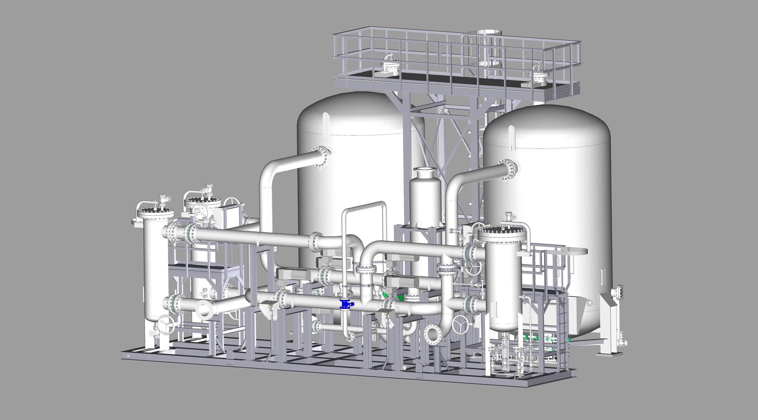
2D & 3D CAD Models (Scan to CAD)
BIM Models (Scan to BIM) & Plant Design Models (Scan to Plant)
Machinery Alignment & Inspection
Storage Tank Inspection & Calibration
Volume Surveys
Construction Verification
Deformation & Wear Analysis
VR/AR & 3D Digital Content
XRF & Thickness Analysis
APPLICATIONS
Digital Twin
Offshore Installations & Platforms
Marine Vessels/Ships
Seawall & Coastal Facilities
PRODUCTS
-
![REGISTERED POINT CLOUDS]()
REGISTERED POINT CLOUDS
Registered and cleaned, colored or black & white point clouds—ready for your workflow.
-
![3D MESH MODELS]()
3D MESH MODELS
High-fidelity as-built 3D mesh models in multiple file formats.
-
![3D CAD MODELS]()
3D CAD MODELS
Accurate as-built 3D CAD models for engineering applications.
-
![BIM MODELS]()
BIM MODELS
As-built BIM models for architecture, engineering, and construction.
-
![PLANT DESIGN MODELS]()
PLANT DESIGN MODELS
Optimized as-built plant design models for seamless integration.
-
![LASER TRACKER ALIGNMENT & INSPECTION]()
LASER TRACKER ALIGNMENT & INSPECTION
Alignment and inspection with laser trackers, CMMs, and 3D laser scanners.
-
![STORAGE TANK INSPECTION & CALIBRATION]()
STORAGE TANK INSPECTION & CALIBRATION
Detailed inspection and calibration reports using 3D laser scanning.
-
![VOLUME SURVEYS]()
VOLUME SURVEYS
Precise volumetric surveys for storage tanks, stockpiles, and equipment.
-
![2D CAD DOCUMENTATION]()
2D CAD DOCUMENTATION
Comprehensive as-built 2D CAD drawings for engineering and architecture.
-
![CONSTRUCTION VERIFICATION]()
CONSTRUCTION VERIFICATION
Clash detection and construction verification by comparing point clouds to design models.
-
![DEFORMATION & WEAR ANALYSIS]()
DEFORMATION & WEAR ANALYSIS
2D & 3D color map models and specialized inspections.
-
![PROPELLER INSPECTION]()
PROPELLER INSPECTION
Accurate propeller inspections following ISO 484 tolerance standards.
-
![VR/AR & 3D DIGITAL CONTENT]()
VR/AR & 3D DIGITAL CONTENT
Real-world objects converted into immersive 3D digital experiences.
-
![XRF & ULTRASONIC THICKNESS ANALYSIS]()
XRF & ULTRASONIC THICKNESS ANALYSIS
XRF material identification and ultrasonic thickness measurements.
SCAN TO CAD

POINT CLOUD
CAD MODEL