AS-BUILT
BIM MODELS


AS-BUILT BIM MODELS
Buildings and structures often deviate from their original designs due to modifications made during and after construction. As a result, traditional design models and plans may no longer represent the building’s actual state, potentially leading to errors and increased costs during renovations, maintenance, or other operations. To address this issue, 3D laser scanning can be used to create as-built Building Information Modeling (BIM) models that reflect the structure’s current condition, including any changes or deviations from the original design.
Point cloud data acquired through 3D laser scanning enables us to either update existing BIM models or generate new ones, ensuring they accurately represent how the structure truly exists rather than how it was initially planned. BIM models themselves are 3D CAD representations commonly used in civil engineering and architecture to incorporate not only structural elements but also mechanical, electrical, and plumbing (MEP) systems. From a BIM model, 2D documentation—such as floor plans, ceiling plans, and section and elevation views—can be generated automatically.
Because BIM formats are often incompatible across different software platforms, exchanging data between them can introduce complications. To prevent this, we create BIM files directly in the client’s preferred software, preserving data integrity and functionality. Additionally, we tailor the Level of Development (LOD) of a BIM model to match a project’s requirements to balance cost, timeline, and necessary detail, ensuring the model meets all needs without unnecessary overhead.
EQUIPMENT USED
Terrestrial 3D Laser Scanner: Leica RTC360 (3D Accuracy: 1.9 mm)
Terrestrial 3D Laser scanner: Faro Focus S 150 (3D Accuracy: 2 mm)
Terrestrial 3D Laser Scanner: Leica BLK360 (3D Accuracy: 4 mm)
Metrology-Grade Handheld 3D Scanner: Shining FreeScan UE Pro (3D Accuracy: 0.02 mm)
Laser Tracker CMM: Faro Vantage S6 Max (Accuracy: 0.016 mm + 0.0008 mm/m)
Measuring Arm CMM: Faro Quantum Max (3D Accuracy: 0.030 mm)
Total Station: Leica FlexLine TS10 1” R1000 (Accuracy: 1 mm, Angular Accuracy: 1 s)
RTK GNSS: Leica GS18 T GNSS RTK Rover (Accuracy: 8 mm)
GPR: Radiodetection LMX200
XRF Analyzer: Skyray Explorer Handheld XRF
Ultrasonic Thickness Gauge: Olympus 38DL PLUS (Accuracy: 0.001 mm)
Sphere Targets
APPLICATIONS
Digital Twin
As-Built Modeling of Structures and Buildings
Plant Design Models (Scan to Plant)
Volume Surveys
2D CAD Documentation
Construction Verification
Deformation & Wear Analysis
Topographic Mapping
GPR (Underground Mapping)
Georeferencing
VR/AR & 3D Digital Content
XRF & Thickness Analysis
APPLICATIONS
-
![INDUSTRY & ENERGY]()
INDUSTRY & ENERGY
Elevate industry operations with 3D laser scanning, which rapidly collects spatial 3D data and minimizes on-site disruptions.
-
![MINING & TUNNELING]()
MINING & TUNNELING
Optimize safety and efficiency in mines and tunnels with 3D laser scanning.
-
![CIVIL ENGINEERING & ARCHITECTURE]()
CIVIL ENGINEERING & ARCHITECTURE
Advance civil and architectural projects with faster, more accurate surveying through 3D laser scanning.
-
![MARINE & OFFSHORE]()
MARINE & OFFSHORE
Transform offshore and maritime operations with advanced 3D laser scanning solutions.
SCAN TO BIM
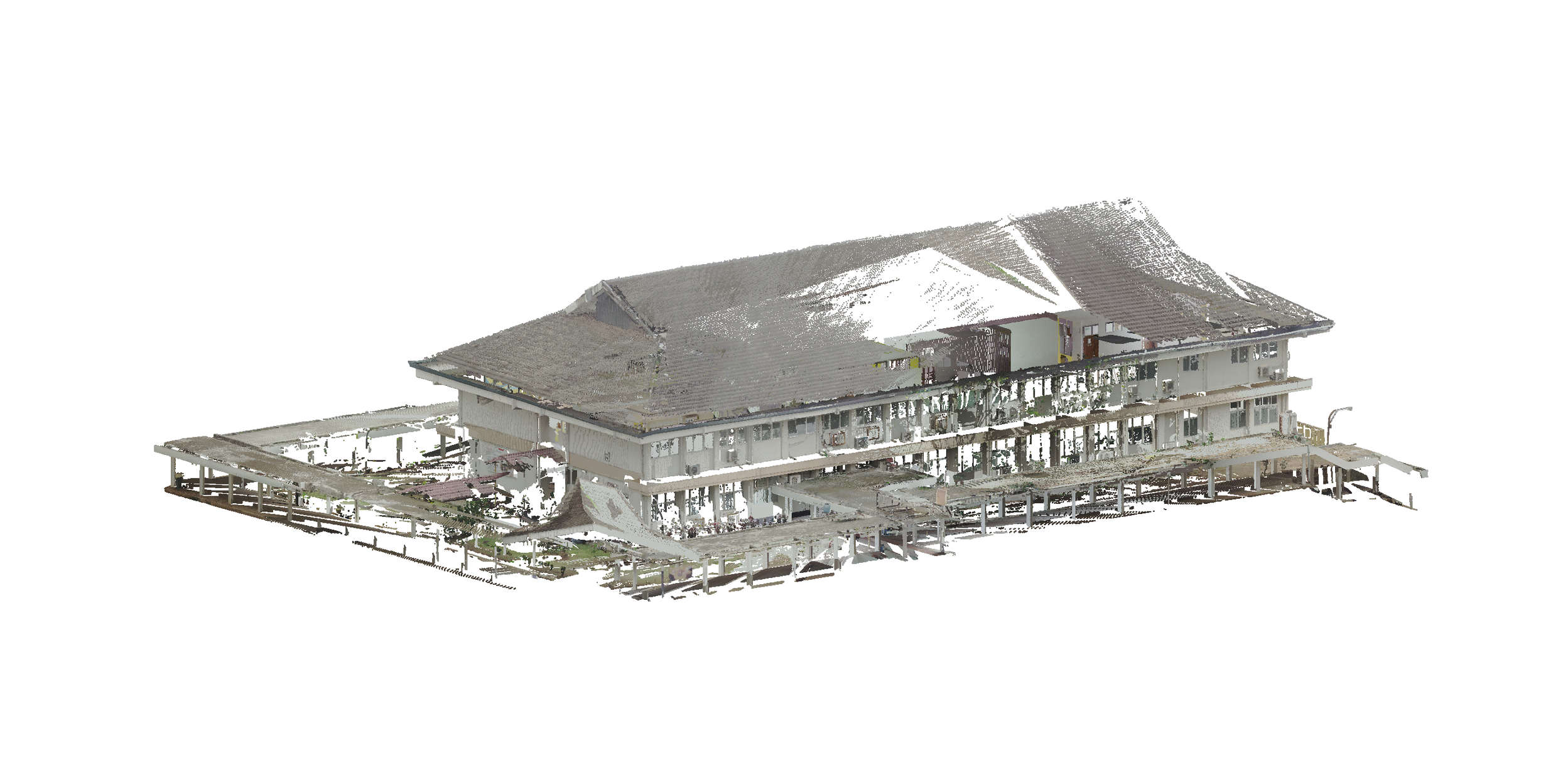
POINT CLOUD
*Point density of above point cloud was reduced by 99% in order to upload to web viewer. Actual point cloud is much more detailed.
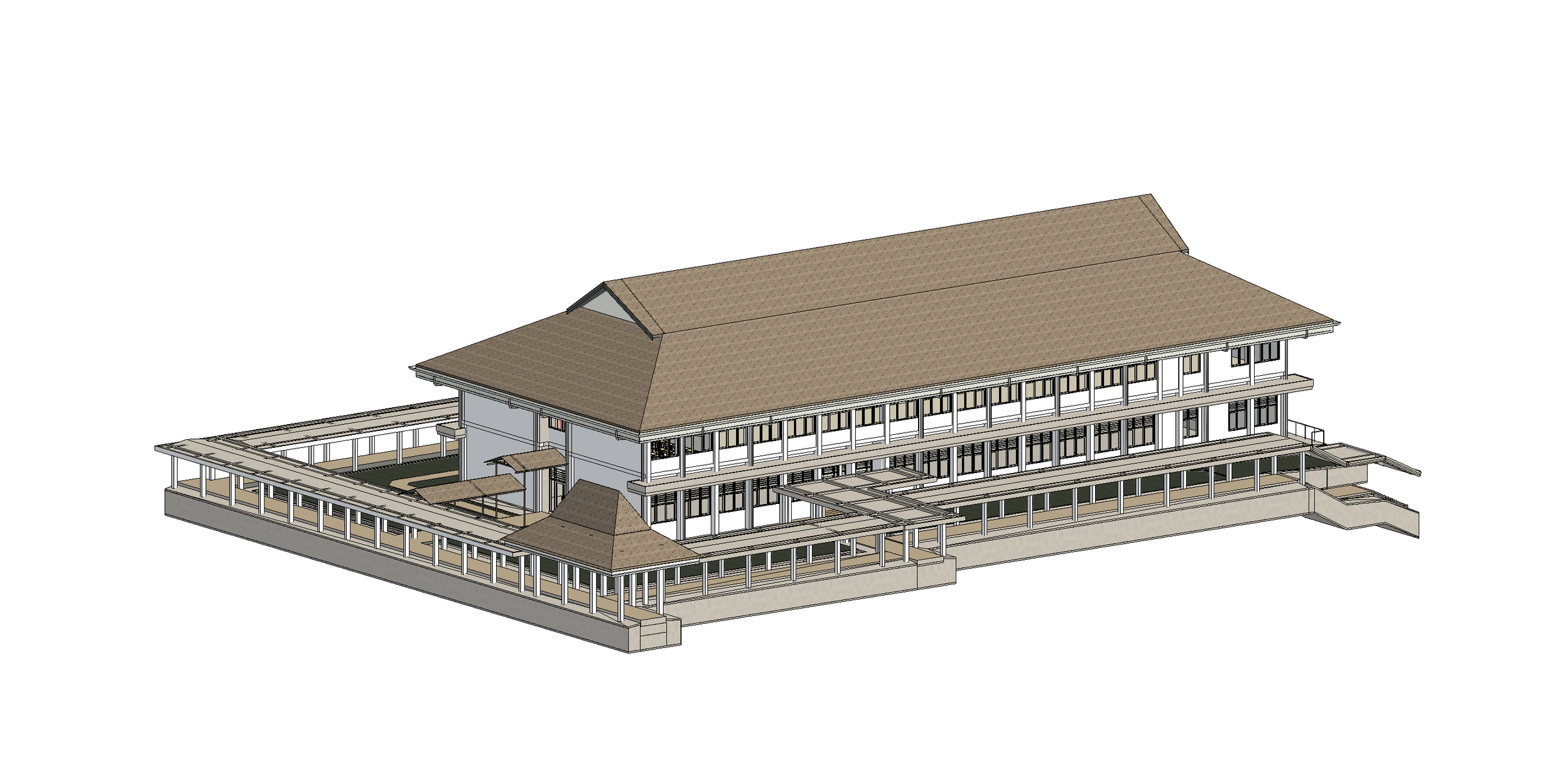
BIM MODEL