AS-BUILT PLANT
DESIGN MODELS
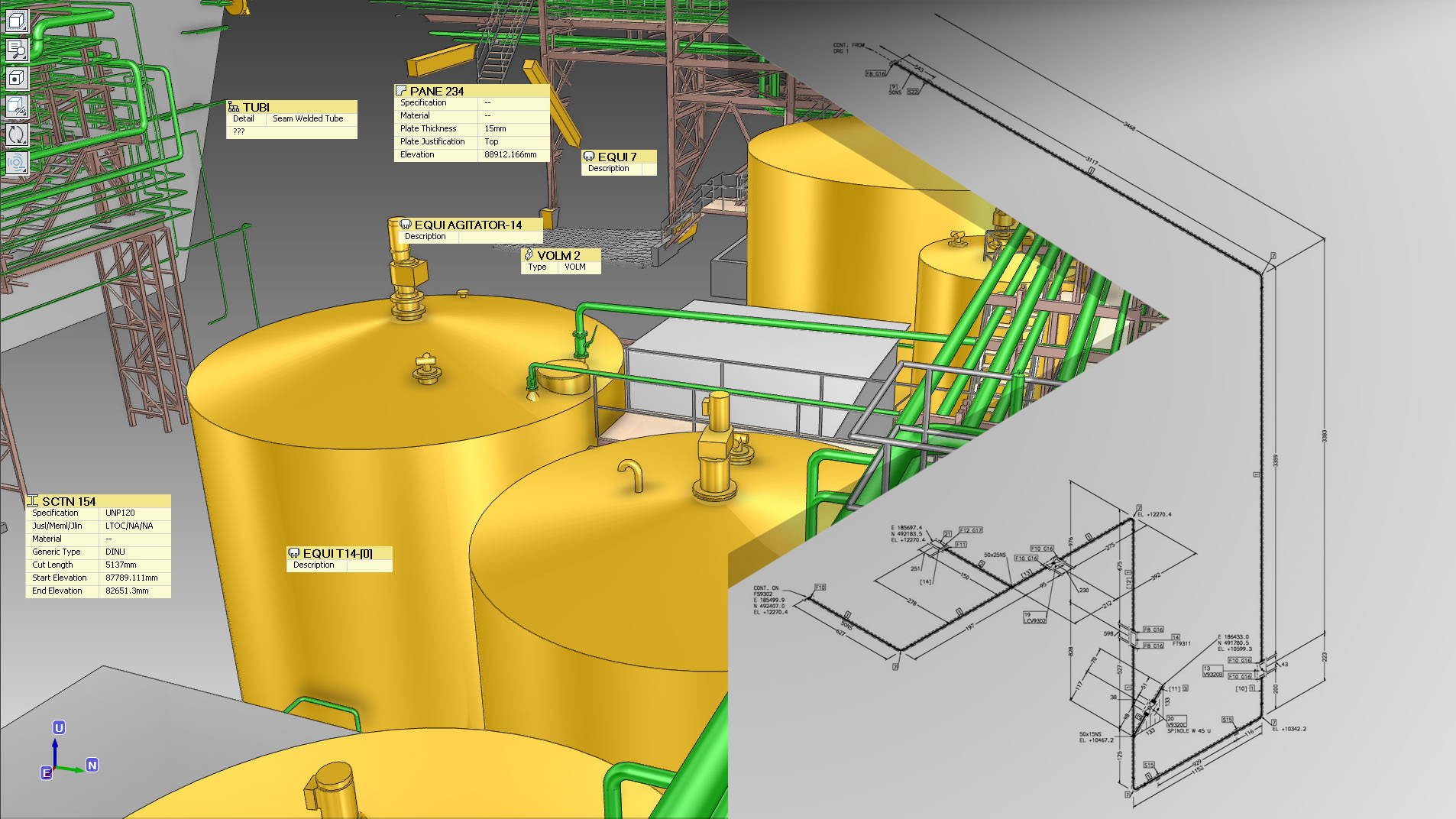


AS-BUILT PLANT DESIGN MODELS
Using 3D laser scanning, we capture detailed point clouds and convert them into as-built 3D plant design models using AVEVA E3D, AVEVA PDMS, or AutoCAD Plant 3D. These models—similar to BIM models—are tailored specifically for industrial applications in petrochemical, manufacturing, and mining.
Our 3D laser scanning and modeling services provide reliable as-built 2D and 3D CAD documentation of existing facilities to aid in the inspection, maintenance, refurbishment, and retrofitting of equipment and structures. Furthermore, we offer other services, including machinery alignment and inspection, storage tank inspection and calibration, volume surveys, construction verification, deformation and wear analysis, topographic mapping, GPR underground mapping, georeferencing, and XRF and thickness analysis.
The specifications required for each plant design model—such as scan resolution and level of development (LOD)—will ultimately determine project cost and duration. This is why we work closely with you at every step to deliver a solution that is both precise and cost-effective, ensuring that our 3D plant design models meet the unique requirements of your project.
EQUIPMENT USED
Terrestrial 3D Laser Scanner: Leica RTC360 (3D Accuracy: 1.9 mm)
Terrestrial 3D Laser scanner: Faro Focus S 150 (3D Accuracy: 2 mm)
Terrestrial 3D Laser Scanner: Leica BLK360 (3D Accuracy: 4 mm)
Metrology-Grade Handheld 3D Scanner: Shining FreeScan UE Pro (3D Accuracy: 0.02 mm)
Laser Tracker CMM: Faro Vantage S6 Max (Accuracy: 0.016 mm + 0.0008 mm/m)
Measuring Arm CMM: Faro Quantum Max (3D Accuracy: 0.030 mm)
Total Station: Leica FlexLine TS10 1” R1000 (Accuracy: 1 mm, Angular Accuracy: 1 s)
RTK GNSS: Leica GS18 T GNSS RTK Rover (Accuracy: 8 mm)
GPR: Radiodetection LMX200
XRF Analyzer: Skyray Explorer Handheld XRF
Ultrasonic Thickness Gauge: Olympus 38DL PLUS (Accuracy: 0.001 mm)
Sphere Targets
APPLICATIONS
As-Built Digitalization of Existing Plant & Digital Twin
3D Mesh Models (Scan to Mesh)
2D & 3D CAD Models (Scan to CAD)
BIM Models (Scan to BIM)
Machinery Alignment & Inspection
Storage Tank Inspection & Calibration
Volume Surveys
Construction Verification
Deformation & Wear Analysis
Topographic Mapping
GPR (Underground Mapping)
Georeferencing
VR/AR & 3D Digital Content
XRF & Thickness Analysis
APPLICATIONS
-
![INDUSTRY & ENERGY]()
INDUSTRY & ENERGY
Elevate industry operations with 3D laser scanning, which rapidly collects spatial 3D data and minimizes on-site disruptions.
-
![MINING & TUNNELING]()
MINING & TUNNELING
Optimize safety and efficiency in mines and tunnels with 3D laser scanning.
-
![CIVIL ENGINEERING & ARCHITECTURE]()
CIVIL ENGINEERING & ARCHITECTURE
Advance civil and architectural projects with faster, more accurate surveying through 3D laser scanning.
-
![MARINE & OFFSHORE]()
MARINE & OFFSHORE
Transform offshore and maritime operations with advanced 3D laser scanning solutions.